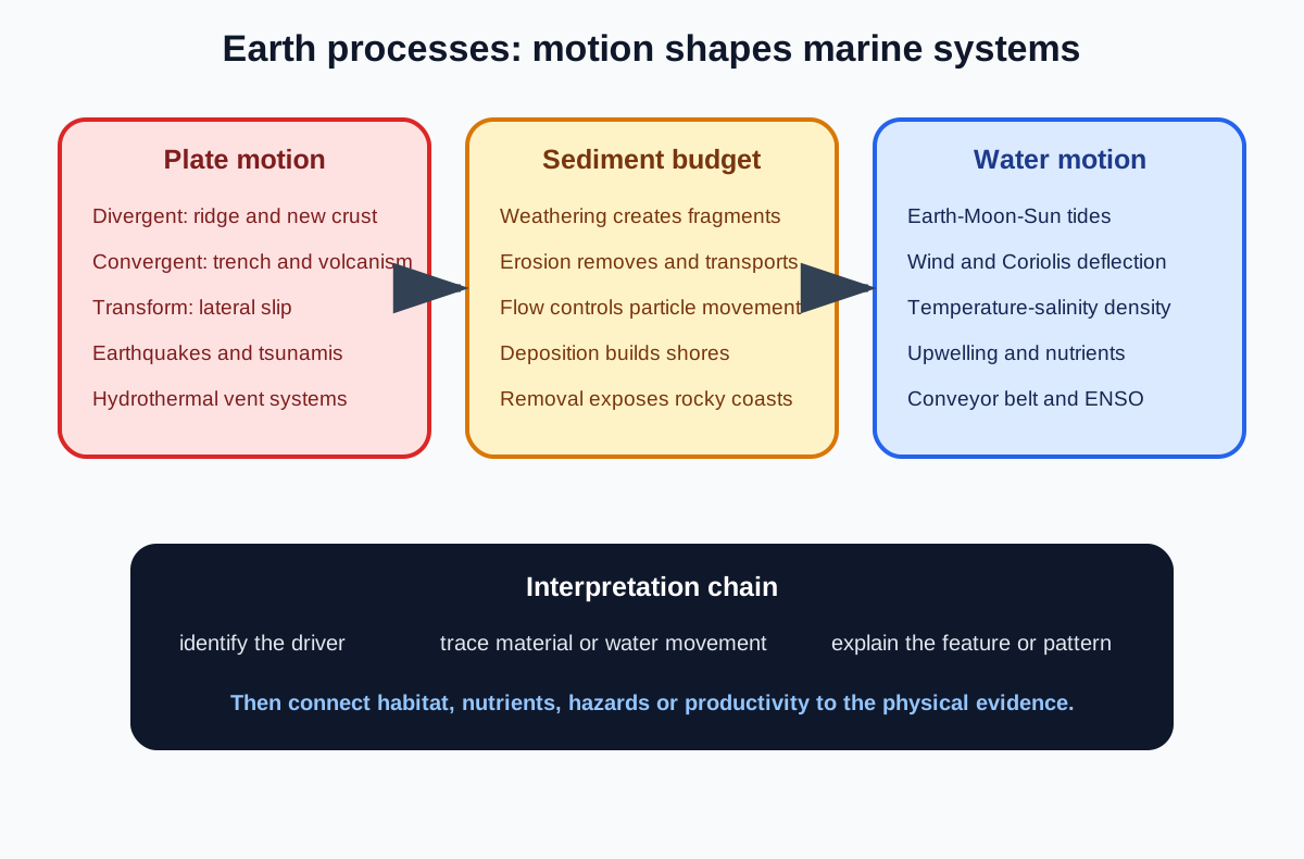
Earth Processes is Topic 2 of the Cambridge International AS and A Level Marine Science 9693 AS syllabus. These notes follow official sections 2.1 Tectonic processes, 2.2 Weathering, erosion and sedimentation and 2.3 Tides and ocean currents. Each landform or circulation pattern is traced from physical cause to marine consequence.
2.1 Tectonic processes
Structure of the Earth
Earth has a central core, a surrounding mantle and an outer crust. The syllabus distinguishes oceanic crust from continental crust.
Oceanic crust is generally thinner and denser than continental crust. This density contrast helps explain why oceanic crust tends to descend at a convergent boundary when it meets continental crust.
The tectonic plates are rigid outer sections moving over deformable material below. Do not describe the mantle as a fully liquid global ocean of magma.
Plate-tectonic theory
Plate tectonics explains how moving plates create and destroy oceanic crust and reorganise continents and ocean basins. A strong answer combines the model with several independent evidence types.
Matching rock formations on now-separated continents suggest former continuity. Similar fossils and living organisms on different continents support past connection or migration routes unlike today's geography.
The jigsaw fit of continental coastlines is suggestive, while the repeating paleomagnetic stripes on either side of mid-ocean ridges record seafloor creation and magnetic reversals.
Paleomagnetic evidence
As magma cools to form basalt at a ridge, magnetic minerals align with Earth's magnetic field and preserve its polarity. Earth's field has reversed many times.
Symmetrical bands of normal and reversed polarity occur on opposite sides of a ridge because new crust forms centrally and moves outward. This is direct evidence for seafloor spreading.
The stripes are ages and polarities recorded in rock, not moving coloured belts on the modern seafloor.
Divergent boundaries
At a divergent boundary, plates move apart. Mantle material rises, melts and forms new oceanic crust, building a mid-ocean ridge.
Tensional stress and magma movement cause shallow earthquakes and volcanism. Cracks allow seawater to circulate through hot rock, creating hydrothermal systems.
The ridge is elevated partly because newly formed crust is hot and relatively buoyant.
Convergent boundaries
At a convergent boundary, plates move together. Dense oceanic crust may subduct beneath another plate, forming a deep ocean trench.
Friction, deformation and sudden slip produce earthquakes. Water and other materials associated with the descending plate contribute to melting processes, and magma can feed volcanoes.
Check this topic from memory
Attempt the matching topic bank before reopening the notes. Use each missed idea to decide what to review next.
The deepest earthquake zones and volcanic arcs therefore form systematic patterns rather than occurring randomly.
Transform boundaries
At a transform boundary, plates slide horizontally past one another. Crust is neither created nor destroyed overall.
Stress accumulates when rough sections lock, then releases as an earthquake. Transform faults also offset segments of mid-ocean ridges.
Do not add volcanoes as an automatic transform feature without a separate magma source.
Abyssal plains and ocean-floor relief
Abyssal plains are broad, deep and relatively level areas of ocean floor. Sediment gradually covers irregular volcanic crust, smoothing its relief.
Mid-ocean ridges, trenches, volcanic islands and seamounts interrupt the plains. The location of these features follows plate processes.
When interpreting a seafloor profile, connect geometry to the appropriate boundary rather than merely naming the shape.
Earthquakes and tsunamis
An undersea earthquake can produce a tsunami if it rapidly displaces a large volume of water, especially through vertical movement of the seabed. Not every marine earthquake does so.
In deep water, tsunami waves can travel rapidly with relatively small height and long wavelength. As they enter shallow water, they slow, shorten and grow higher, creating coastal inundation.
Wind does not generate a tectonic tsunami, although wind affects ordinary surface waves and storm surge.
Hydrothermal vent circulation
Seawater enters fractures in oceanic crust, is heated near magma and reacts with hot rock. The water remains liquid at high temperature because of intense pressure at depth.
It becomes rich in dissolved materials and rises through the crust. On discharge, the hot fluid and entrained material form a hydrothermal vent plume.
Chemical and physical signals in the plume can be detected some distance from the vent, helping locate and study vent systems.
Chimney formation
Hot vent fluid can dissolve substantial amounts of salts and minerals. When it meets cold seawater, rapid cooling changes solubility and dissolved substances precipitate.
Repeated deposition around the outlet builds a chimney. The dark appearance of some black smoker plumes comes from fine suspended mineral particles.
The chimney is formed by precipitation from cooling fluid, not by ordinary lava piling up at the opening.
2.2 Weathering, erosion and sedimentation
Weathering versus erosion
Weathering breaks rock down in place. Erosion removes and transports weathered material.
A cliff can be weathered by chemical reaction or root growth before waves carry fragments away. The first process creates loose material; the second relocates it.
Deposition or sedimentation occurs when transported particles settle.
Physical weathering
Physical weathering breaks rock without changing its chemical composition. Repeated heating and cooling can expand and contract minerals differently, while freeze-thaw action can widen cracks where liquid water freezes.
Salt crystals growing in pores can also exert pressure in coastal environments. The result is smaller fragments with more exposed surface area.
Do not classify abrasion during transport as weathering if the question asks specifically about erosion.
Chemical weathering
Chemical weathering changes minerals through reactions with water, oxygen or acids. Carbon dioxide dissolved in rainwater forms weakly acidic water that can dissolve carbonate rock.
Oxidation changes iron-bearing minerals, while hydrolysis alters some silicate minerals. Warm, wet conditions often increase reaction rates.
The products may be dissolved ions, altered minerals or weakened rock.
Organic weathering
Organic or biological weathering results from organisms. Roots widen cracks, burrowing organisms expose material and biological acids can dissolve minerals.
An example should name both the organism-related action and how it breaks or alters rock.
Living activity can contribute physical and chemical effects, but classify according to the stated mechanism.
Four erosion agents
Ice transports material in glaciers and can scour rock. Flowing water and waves move particles and abrade surfaces. Wind lifts and carries fine dry sediment. Gravity moves material downslope through falls, slides or flows.
Several agents can act sequentially. Gravity may deliver cliff debris to the shore, then waves transport it along the coast.
Name the transport process rather than listing an agent without action.
Water speed and particle movement
Faster-moving water has more capacity and competence to erode and transport sediment. Large or dense particles require greater energy to begin and remain in movement.
When flow slows, the largest particles usually settle first, followed by progressively finer material. Very fine particles may remain suspended in weak currents.
Deposition patterns therefore record changing energy conditions.
The littoral zone
The littoral zone is the intertidal region of a shoreline between the highest and lowest spring-tide marks.
It is periodically submerged and exposed, creating strong gradients in drying, temperature, salinity, wave action and oxygen availability.
Required examples include rocky shores, sandy shores, muddy shores, estuaries and deltas.
Rocky-shore morphology
Where erosion removes material faster than it accumulates, resistant bedrock and cliffs remain exposed. Waves exploit joints and faults, and gravity removes loosened blocks.
Platforms, pools, crevices and different exposure levels create varied habitats. Particle deposition is limited in strongly energetic areas.
Rocky morphology reflects both rock resistance and the local erosion-deposition balance.
Sandy and muddy shores
Sandy shores form where medium particles are supplied and deposited but can still be reworked by waves and currents. Grain movement produces mobile, oxygenated upper sediment.
Muddy shores develop in sheltered, low-energy water where fine particles can settle. Small pore spaces and microbial respiration can create low-oxygen sediment below the surface.
Particle size, sorting and water energy explain the contrast better than colour alone.
Estuaries and deltas
An estuary is a partly enclosed coastal water body where river water mixes with seawater. Reduced flow and changing salinity encourage sedimentation, especially when fine particles aggregate.
A delta grows where river-supplied sediment is deposited faster than waves, tides and currents remove it. Channels divide around accumulating sediment.
High sediment input alone does not guarantee a delta if marine removal is equally strong or stronger.
2.3 Tides and ocean currents
Production of tides
The Moon's gravitational influence and the Earth-Moon system produce tidal bulges, while the Sun modifies their magnitude. As Earth rotates relative to the bulges, many coasts experience alternating high and low water.
Local timing and size are altered by basin shape, coastal geomorphology, water depth and resonance. Wind and air pressure can raise or lower observed sea level relative to the astronomical prediction.
Tidal patterns are therefore predictable but locally modified.
Spring tides
Spring tides occur when Earth, Moon and Sun are aligned near new moon or full moon. Lunar and solar tidal influences reinforce one another.
The result is a larger tidal range: higher high waters and lower low waters relative to the local average.
Spring refers to the water springing through a larger range, not to the season.
Neap tides
Neap tides occur when the directions to Moon and Sun are approximately at right angles as seen from Earth, near the quarter moons.
Their tidal influences partly oppose, producing a smaller tidal range. High water is lower and low water is higher than during nearby spring tides.
Neap tide does not mean no tide.
Reading tide tables and graphs
A tide table gives dates, times and predicted heights of high and low water for a location. Tidal range is high-water height minus the adjacent low-water height.
On a graph, locate turning points and read both axes carefully. Large ranges over successive cycles indicate spring conditions; smaller ranges indicate neap conditions.
Use interpolation cautiously because the water level does not always change linearly between high and low tide.
Wind-driven currents
Persistent wind transfers momentum to the ocean surface. Surface movement is deflected clockwise in the Northern Hemisphere and anticlockwise in the Southern Hemisphere by the Coriolis effect within the syllabus boundary.
Continents and seabed topography redirect flow into large current systems. Friction transfers motion downward but weakens with depth.
Do not say the Coriolis effect initiates the current; it deflects moving water.
Density-driven circulation
Cooling and increasing salinity raise seawater density. Dense surface water can sink at high latitudes and spread through the deep ocean.
Elsewhere, deeper water returns upward and surface currents complete the circulation. Temperature and salinity together create this thermohaline component.
The global ocean conveyor belt is a connected circulation, not one narrow current moving at one speed.
Upwelling
When surface water is moved away from a coast or divergence zone, deeper water rises to replace it. Coastline shape, winds, current deflection and seabed form influence where this occurs.
Deep water is often nutrient-rich because sinking organic matter has been decomposed. Upwelling delivers these nutrients to illuminated surface water, supporting high primary productivity and fisheries.
Upwelled water is not automatically oxygen-rich; its chemical character depends on origin and history.
Importance of the conveyor belt
Global circulation redistributes heat, salts, dissolved gases, nutrients and organisms among ocean basins. It connects surface climate forcing with deep-water conditions.
Changes in water formation can alter heat transport and mixing over long timescales. Explain importance through transported properties rather than saying only that oceans mix.
The model is a useful global simplification, while real pathways branch and vary.
Normal tropical Pacific conditions
Under typical conditions, trade winds push warm surface water westward. Upwelling of cooler nutrient-rich water occurs in the eastern equatorial Pacific.
The western Pacific has deeper warm water and more rising moist air, while the eastern Pacific supports productive food webs and fisheries.
This baseline is required before explaining El Niño or La Niña.
El Niño
During El Niño, trade winds weaken or reverse and warm surface water shifts eastward. The thermocline deepens in the eastern Pacific and nutrient-rich upwelling weakens.
Primary productivity and fisheries can decline in the east. Rainfall and storm patterns shift across the Pacific and beyond, producing floods in some regions and drought in others.
Effects vary between events, so avoid claiming one identical global outcome.
La Niña
During La Niña, trade winds strengthen beyond typical conditions. Warm surface water is driven farther west and eastern-Pacific upwelling intensifies.
The east is cooler and often more productive, while atmospheric rainfall patterns shift broadly opposite to many El Niño anomalies.
La Niña is not simply a complete return to normal; it is the cool phase of the ENSO cycle.
Worked application: interpreting tidal range
A tide table lists low water at 0.7 metres and the following high water at 5.9 metres, so the tidal range is 5.2 metres. Fourteen days later, adjacent low and high waters are 2.1 and 4.3 metres, giving a 2.2-metre range. The first date is more consistent with spring-tide conditions and the second with neap conditions. The table alone does not show that wind caused either astronomical cycle. If an observed height differs from prediction, onshore wind, low air pressure or local coastal geometry may help explain the residual, but those effects require weather or site evidence.
Common misconceptions and corrections
Calling the mantle entirely liquid. Plates move over deformable mantle material.
Using only coastline fit as tectonic evidence. Combine independent evidence types.
Saying paleomagnetic stripes are modern current patterns. They are polarity records in rock.
Creating crust at a convergent boundary. Oceanic crust is commonly subducted there.
Destroying crust at a divergent boundary. New crust forms at ridges.
Adding routine volcanoes to every transform fault. Transform motion mainly produces earthquakes.
Calling an abyssal plain a trench. One is broad and level; the other is narrow and deep.
Saying every undersea earthquake produces a tsunami. Large rapid water displacement is required.
Calling tsunami a wind wave. Its tectonic source and wavelength differ.
Saying vent water boils freely at depth. High pressure allows very hot liquid water.
Calling vent chimneys solidified lava. Dissolved materials precipitate on cooling.
Using weathering and erosion interchangeably. One breaks in place; the other transports.
Classifying wave transport as weathering. It is erosion.
Listing an erosion agent without its action. Describe removal and transport.
Saying all particles settle together. Settling depends on flow and particle properties.
Defining littoral as the whole continental shelf. It lies between spring-tide marks.
Calling every sediment shore sandy. Low-energy fine sediment forms muddy shores.
Saying every river mouth forms a delta. Deposition must exceed marine removal.
Attributing tides only to the Moon. Solar influence modifies the range.
Calling spring tide a season. It is an alignment-driven large range.
Calling neap tide no tide. It has a smaller range.
Subtracting non-adjacent tide heights. Use the relevant high and low pair.
Assuming linear water-level change between tides. Interpolate cautiously.
Saying Coriolis starts ocean currents. It deflects moving water.
Reversing hemispheric deflection. Clockwise north, anticlockwise south in this model.
Making temperature the only density control. Salinity also drives sinking.
Calling the conveyor belt one uniform-speed stream. It is a connected circulation system.
For tectonics, identify the boundary, state plate motion and trace it to the named seafloor feature or hazard; support the theory with the four limited evidence types. Explain vent plumes and chimneys through pressure, temperature, dissolution and precipitation. For coasts, separate weathering, erosion and sedimentation and use energy and particle size to explain each required littoral morphology. Tide answers need alignment, range calculation and local modifiers. Current answers should combine wind, density, Coriolis and seabed controls, then link upwelling or conveyor circulation to transported heat and nutrients. ENSO responses must compare normal, El Niño and La Niña conditions causally.
Retrieval practice
Draw the three plate boundaries and annotate crust creation, destruction, earthquakes, volcanoes and seafloor features. Reconstruct the hydrothermal circulation and chimney sequence. Classify weathering and erosion examples, then predict deposition for changing flow and particle size across all five littoral settings. Calculate tidal ranges from a table, explain spring and neap alignments, sketch global circulation and upwelling, and compare trade winds, thermocline depth, productivity and rainfall during normal, El Niño and La Niña conditions.